Natural heritage
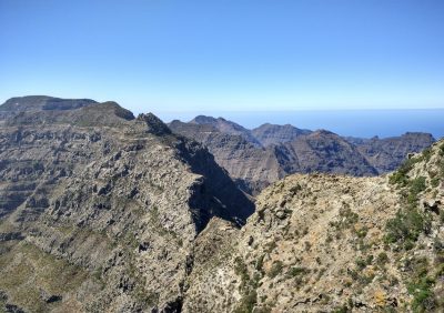
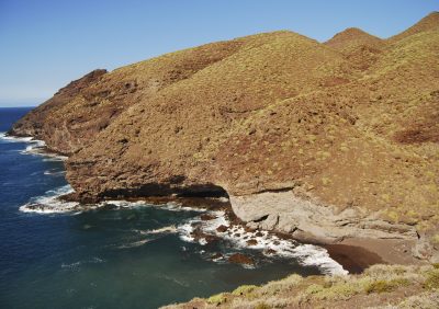
The coastline of the municipality of La Aldea de San Nicolás runs along a jagged line for 32 km between El Andén Verde (municipality of Artenara) and Los Secos (municipality of Mogán), with some steep and brittle profiles; an ensemble of toothy ridges alternating with coves and beaches, where dozens of ravines open out, produced by a continual marine erosion process that has been going on for over 14 million years, here at the oldest geological area of Gran Canaria.
Creeks, inlets and rocky points lie along the shore, alongside a mountainous area of elevations, plateaus, ravine estuaries, volcanic strata split by dykes (chimneys), and buried volcanic cones that abound around the ridges… these all define one of the Canaries’ most impressive and suggestive coastal areas and the most natural and educational accounts of volcanism and geomorphology.

The West Coast of Gran Canaria
The Cliffs at El Andén Verde to La Punta de La Aldea
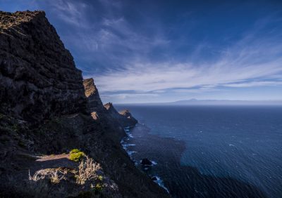
These cliffs fall within the Tamadaba Natural Park and constitute the first coastal section from north to south. They are defined by a line of serrated mountainous crests that rise almost vertically over the sea, separated by gorges and decapitated valleys due to the erosion along the coastline and to a gigantic rock collapse on the island, covering the whole coastal arch from Agaete to La Punta de La Aldea. The area is rich in fish and seafood, but is also a hazardous area to navigate around.
Ample panoramic views can be enjoyed from the main road, from the viewing points of El Andén Verde and El Paso de Marinero (Also known as Mirador del Balcón), or alternatively on the path that runs from El Almacén de El Muelle as far as La Punta de La Aldea.
La Playa de El Puerto and the platform to La Punta de La Aldea
This is one of Gran Canaria’s most enchanting inlets. It has a completely unspoiled, black sandy beach, and can be accessed from a mountain footpath, from El Almacén de El Muelle, or the marine platform itself that starts at El Muelle; utmost care must be taken due to rockfalls and slippery areas.
La Playa de El Puerto was a natural port used by sailing vessels in ancient times, with the name of El Puerto de El Perchel (the name of the place where boats were moored). Paths run up from El Puerto as far as the gorges that open up at La Punta de La Aldea, from where visitors can appreciate the huge dimensions of the coastal arch of the northwest of Gran Canaria.
Just a few metres away, following the platform along El Puerto to La Punta de La Aldea, is El Bufadero, the name given to a cove where compressed air is forced through a hole by extreme water pressure, making a deafening noise, like a roaring sea dragon.
La Playa de La Aldea
This is the municipality’s main beach, and although it is the most popular with visitors and locals it still maintains its charm as a sunken estuary from bygone geological times. It makes up the outlet of the valley of La Aldea and the hydrographic basin of Tejeda-La Aldea, the largest in the Canaries.
La Playa de La Aldea has different bathing areas and other settings (El Muelle, La Caletilla beach, Las Barquillas beach, Bocabarranco de El Charco, El Roque…). Apart from being an urban fishing area it has a range of historical sites, each of them with their corresponding information boards.
Several footpaths lead off from here to places such as El Puerto, La Punta de
La Aldea, El Roque, La Marciega-El Charco and Las Manchas (a spacious and highly important wetland, due to the presence of many migratory birds).
La Marciega stands on parallel 20º 00ʹ 00ʺ, and has a long history of sea navigation to the Americas, being first used by Christopher Columbus on his great voyage of discovery in 1942.
Cliffs of El Roque-Amurgar-Peñón Bermejo and Guguy
These cliffs constitute the next marine section, running southwards from La Playa de La Aldea
as far as the area of Guguy. It is the coastline of the Güigüi Special Nature Reserve and the grand mountainous massif of the southwest of Gran Canaria.
It towers vertically over the sea, with a horizontal geological formation (lava flows) of various colours, plus dykes or farallones (volcanic chimneys) and buried volcanic cones, both of them uncovered due to the effects of erosion, all making up another of the Canaries’ most breathtaking sea views, and perhaps one of the most stunning volcanic territories in the world.
It can only be observed from the sea or from the footpath from El Almacén de El Muelle to El Puerto (La Aldea).
Playas de Peñón Bermejo to Guguy
These are comprised of three strips of sandy, unspoiled beaches, located at the inlets of the ravines of Macizo del Suroeste. Peñón Bermejo gets its name from the reddish colour of its volcanic cliffs, a result of atmospheric oxidation and the ferrous composition of the original lava from these primeval volcanoes.
Guguy is an ancient Canarian indigenous linguistic term that has the same meaning as that which still exists in modern-day African Berber territories, namely ‘mountainous arch’. This place name is repeated in other mountainous regions to the west of Gran Canaria. When the term was transcribed from the indigenous language to Castilian Spanish in the 18th century, it was mistakenly spelt ‘Güigüi’ and was written as such on maps, although efforts are being made to bring back the spelling of Guguy.
The beaches of Peñón Bermejo, Guguy Chico and Guguy Grande are more spacious and feature stunning views, giving the region the appearance of a long-lost paradise. However, despite the beaches only being accessible by lengthy footpaths from La Aldea or Tasartico or by sea, the regular influx of visitors does take away its charming sense of wilderness to some extent.
The valley of Guguy Grande was a populated site until the middle of the 20th century, and even the multinational fruit company Fyffes built a packaging warehouse in 1904 for tomatoes and bananas that would then be carried by aerial cables to steam boats anchored on the beach for export.
It is an enchanting place indeed, with tales and legends that are the main theme of El
Cuervo de Zamora, relating to a strange sound involving tormented souls and stashed monies.
Los Canalizos and El Descojonado
This area constitutes an inaccessible stretch of coastline between Guguy and Tasartico, which continues in the spectacular vein of the cliffs to the west of Gran
Canaria; here perhaps at its greatest point, with its abundance of horizontal lava strata dissected by a thick set of vertical channels, or canalizos (hence its name), the studied volcanic chimneys that emerged during the early stages of Gran Canaria’s geological formation (-14 to -9 million years).
The erosion of the sea of these cliffs has created whimsical physical features, known locally as raques and coletones and other strange formations that give the area the name of Punta de Las Tetas and Punta del Descojonado, at the southernmost point of Gran Canaria. The marine quadrant of Mar de las Calmas de Canarias begins at this point, in contrast to the northwestern seas, more influenced by the trade winds and the so called Canary Cold Air Current.
Playa de El Asno and Playa de Tasartico
This constitutes the next cove along from Macizo de Guguy. It is located at the inlet of Tasartico ravine and is made up of a pebble beach and calm seas, making it ideal for fishing. There is a camp site situated just a few metres from the shore.
This beach was also the site for tomato packaging at the turn of the 20th century, with a great hollow on its left-hand side: La Cueva del Dinero, filled with legends.
Cliffs of Tasartico to Tasarte, La Playa de Las Aneas
From Tasartico, running southwards towards Tasarte, along the tranquil Mar de las Calmas, continue to carve out coastal profiles here at the oldest part of Gran Canaria, featuring a number of coves and ravine mouths that hang between the line of mighty, towering cliffs.
The solitary and inaccessible Playa de Las Aneas is the largest beach, in keeping with the pebble beaches, and is another charming location in the lost world of Gran Canaria.
La Playa de Tasarte
This beach is the next important inlet, and is a large pebble area. It is popular with visitors and locals, featuring a restaurant and a few houses.
The volcanic materials from this ancient period or stage of early formation were more acidic, and have a lighter colour than those seen until now, giving the municipality’s coast a whole new colourful contrast.
This region saw high levels of agricultural development (bananas, tomatoes, fruits…) leading to the introduction of several packaging warehouses, the oldest of which, from the early 20th century, is the Fyffes multinational fruit company, that is still standing.
The sea at this southern point appears even more tranquil, with a perfect temperature for bathing. It is very busy, especially at weekends, and access to it is gained along a tarmac road.
Despite the aforementioned human activity around this territory, its mountainous profiles maintain their uniqueness and charm, with the contrast of violet, reddish and light colours on their peaks.
La Playa del Ámbar
This is a charming spot next to La Playa de Tasarte, which can be accessed at low tide through an open cavern.
It is a small strip of pebbles at the foot of a cliff. It is called so because in olden times pieces of amber used to be washed up there, the remains of cetaceans.
La Playa de Los Secos
This is the last beach on the road south, at the heart of Mar de las Calmas. It can be accessed from Tasarte or from Veneguera along a footpath, which in its geographical centre, marks out the boundary between the municipalities of La Aldea and Mogán.
Andén Verde Cliffs
At the northern tip of the municipality emerges this stunning cliff, the result of a gigantic gravitational landslip which gave rise to Arco del Andén Verde, the range of pointy mountains that cut a rugged line along the northwest of the island. Without doubt, wherever we may be along its peaks and gorges, we are treated to one of the archipelago’s most stunning settings.
It features a precipice that plunges into the Atlantic and provides a fascinating insight into the birthplace of the island. Beautiful long dykes cut across it in all directions, offering memorable settings for keen geologists, and an uncommonly wide range of minerals that can be readily spotted.
Equally special are the narrow ridges that make up the surrounding area. They are diverse in materials and colours, and reflect the different eruptive moments in the first fundamental stage of the island’s geological history.
The narrow ledges along this spectacular cliff are subject to an ongoing process of marine erosion, and are home to an ample catalogue of plants that have adapted to the persistent trade winds, and to the poor and salty soil. This natural fortress is among the areas which, in terms of its surface area, is home to the highest number of endemic species from Gran Canaria, some of which can only be found on these ridges.
The siempreviva from La Aldea (Limonium benmageci), the corazoncillo (Lotus
callis viridis) or the white saladillo aldeano (Polycarpaea sp.) are three such plants that can only be found in and around the breathtaking western cliffs of Gran Canaria.
This mountain range is also a sanctuary for marine birds. It is a vitally important region for ocean birds who come to nest on the island.
One of the largest colonies of shearwaters in the archipelago come to the ridges around here for reproduction purposes.
In addition, it is highly likely that the Bulwer’s petrel and the European storm petrel come here to reproduce, as well as other until now unknown species.
Tabaibal de La Punta
One of the most idyllic settings in Gran Canaria is to be found at Punta de La Aldea. It features a lush shrubland, dominated by sweet tabaiba plants, that covers the age-old hillsides on western side of the island, and together with the little cove at El Puertito, the shallows and ledges provide a truly stunning picture postcard setting.
Many bushes exclusive to the Macaronesia region flourish here, including leñas buenas, coastal siemprevivas, salados, toldas or espinos, which all bring a splash of colour and offer a refuge and sustenance for local wildlife.
La Marciega Wetlands
Esta zona húmeda está entre las más interesantes de Canarias. Ocupa gran parte de la desembocadura del barranco de La Aldea y reúne condiciones que la hacen especialmente atractiva para numerosas aves acuáticas-residentes y migratorias- y multitud de pequeñas aves forestales que encuentran lugar de cría, alimentación y descanso en un extenso bosquete de tarajales.
Se trata de uno de los ambientes más cambiantes del municipio que evoluciona constantemente en función de la presencia del agua. En las estaciones más frescas y húmedas destaca la invernada de distintas especies de garzas, limícolas y anátidas que llegan en busca de mejor clima desde regiones frías. En el periodo seco, los invertebrados y las aves residentes son los principales protagonistas.
Cardonal de Los Hoyetes
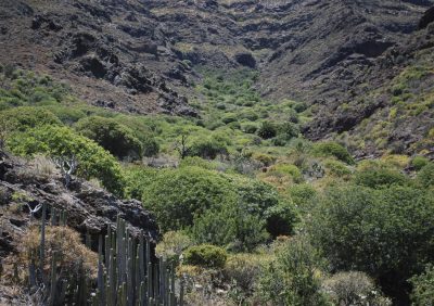
Right next to Hoya del Salado, an extensive cardon plant woodland covers the hillsides running down from peaks of the Tirma-Azaenegue massif to Barranco Grande. There are old cardon plants covering areas of over 50 square metres. The spectacular presence of the plants, together with the beautiful views over La Caldera make this a truly magical spot.
It is an exclusive location for enjoying what may well be the most unique ecosystem in the Archipelago, with lush shrubland, a peculiar range of water-retaining plants with curious adaptations that paint a truly exotic landscape.
Palmeral de Pino Gordo
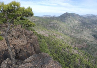
All along the Pino Gordo ravine, which begins at the paddock of L’inagua and finishes at Barranco Grande, lush palm groves blend in with pine woodland provide a green backdrop to the ravine bed and paint one of the most exotic pictures of the west.
The floral interest of these woods is enhanced by the huge, steep walls that tower over some sections of the ravine, providing ideal refuges for many rare endemic rock-growing species.
The cliffs of Pino Gordo provide a refuge for some of the scarcest and most highly threatened species in Gran Canaria, such as the cabezote or the tomillón blanco
(Micromeria leucantha), a taxon that is restricted to highly specific points around the western side of the island.
Almacigal de Artejévez
La Hoya de Artejévez, at the foothills of Los Cedros mountain, is home to the largest extension of almacigo trees to be conserved on the islands. This bastion of biodiversity, a fine example of thermophilic woodland, enables us to imagine the great expanse of plant life that once dominated a large part of the hollows and hillsides of the Valle prior to the deforestation process to which it was subjected by man.
In addition, in this lush almacigo woodland, it is possible to spot some slim Canary pine trees, wild olive trees, guaydil shrubs and a fascinating group of succulent fruit plants, including for example, the tasaigo and the yerbamora. Ultimately, there is an extensive list of species exclusive to the Macaronesia region, the Canaries or Gran Canaria, all of which are closely linked to this interesting ecosystem.
Pinar de Inagua
This pine wood is beautiful example of Canary pine trees, possibly the finest representation of dry pine trees to exist in the Archipelago. It is an area of woodland in a good state of conservation with considerable botanical qualities. Both the woodland and its surrounding area provide refuge to a huge array of Gran Canarian endemic species, some of which can only be found at this particular site.
Standout species include the highly rare jarillas amarillas (Helianthemum bistropogophyllum e inaguae), the only dragon tree of its kind in Gran Canaria here in this municipality (Dracaena tamaranae), or the siempreviva del pinar (Limonium vigaroense).
Piinar de Inagua is home to majority of forestry birds present on the island, including the blue chaffinch –an ornithological jewel- and the woodpecker. It is well worth mentioning the sheer variety and abundance of invertebrate species, for example the cigarrón palo grasshopper, the Canary mariposa sátiro butterfly (Hyparchia wisii), the teresita (Pseudoyersinia canariensis) or Buprestis berthelotti, along with many other endemic species.
The pine forest at Inagua is the main nesting area for the blue chaffinch in Gran Canaria, a rare and scarcely scientifically documented bird at the turn of the last century, which awakens interest and kindness from a multitude of people all around the planet, and which has become an attraction for many ornithologists who dream of being in their company.
Macizo de Guguy
Steep, untamed and wild. This mountain range with ravines and beaches constitutes a unique natural space where geology stands out above all else. It is an extensive amalgam of rocky formations that provide visitors with a truly spectacular setting that only the volcanoes on this ocean island have been able to create.
The steep relief of the Guguy massif is the ideal environment for the majority of birds of prey and crows that flourish on the island. The sheer walls of its ravines and cliffs provide the ideal habitat for baby eagles, kestrels, sparrowhawks and owls, and in bygone times, a breeding ground for ospreys or fishing eagles, who are currently sporadic visitors to these shores during the migratory period.
The cliffs at Guguy are also one of the last bastions on the island for other smaller birds that depend to a certain extent on the rocky settings there, for example the shrieking sparrow, known by local country folk as risquero, and the trumpeter finch, or “Moroccan bird” to the locals.
In addition, the cracks in these rocky ledges are home to at least two different species of bats, the European free-tailed bat and the mountain bat. The ridges are home to Scopoli’s shearwaters, who have set up some of the highest number of breeding colonies on the island right here.
Cañón de Higuera Prieta
Rising up from the peaks of Los Molinos, with its mouth facing Tasarte ravine, Higuera Prieta is a stunning canyon, the result of the infinite patience of water. It is a breathtaking landscape that enables visitors to marvel at the scars left by time and erosion at the oldest point of the island.
Its amazing cliffs are a testament to the indomitable power of the island’s volcanic activity.
Its ravine bed, wedged in whimsically along the ravine, has made it an impregnable refuge for wildlife. An example of this is a colony of Bulwer’s petrels that has been recently discovered.
Azulejos de Cueva Nueva
Along the eroded hillsides of the Tirma-Azaenegue, specifically at Cueva Nueva, Los Hoyetes and El Sabinal, are an abundance of striking tiles that mark out the edges of the legendary basin that originated following the collapse of the Tejeda Volcano. The intense colours of these materials are due to phreatic reactions that altered their state as they made their way up to the surface.
These colourful strata, especially striking at the head of Barranco de Veneguera (Mogán), constitute one of the most popular picture postcard settings in Gran Canaria. And no wonder, as such significant representations are highly uncommon on this part of the island.
Andenes de Tasarte
To the far west of Inagua massif, following millions of years of dismantling, as if it were a staircase, the powerful surge of lava flow that came pouring out of the primeval Tejeda Volcano lies naked in front of our eyes, offering a truly unforgettable setting. These ridges are among the most beautiful natural settings in the Archipelago.
Walking along them can be one of the most amazing experiences for visitors, because, apart from their own spectacular beauty, these ridges provide memorable panoramic views over Guguy massif and Rampas del Suroeste.
Contact
If you would like to contact us, please use the contact details below.
- La Aldea Visitor Centre and Tourism Office
Calle Paseo El Muelle, 140. 35470 La Aldea de San Nicolás
- 682.22.58.98
- turismo@aytolaaldea.com

